LMLK Home
Biblical Accounts
NonBiblical Accounts
Theories
HBRN
MMST
SUKE
ZYF
Generic
x (cannot classify)
2-Top
2-Divided
2-Undivided
4-Cursory
4-Lapidarist
Jars
Personal Seals
Incisions
Paleography
Typologies
Corpus
Stratigraphy
Geography
Displays
Publications
Credits
Updates

|
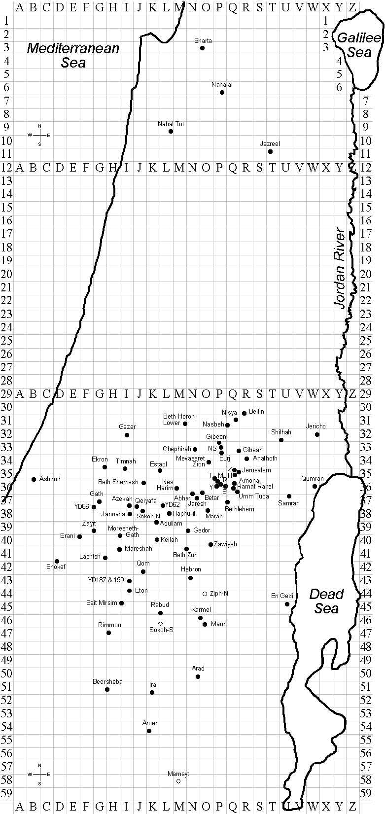
List of all sites sorted by root-name (common alternative spellings in parentheses) where LMLK handles have been excavated (except for Mamsyt, Sokoh [S], & Ziph [N]) {map grid coordinates in braces}:
- Abhar (Khirbet el-'Abhar) {N-36}
- Adullam {K-39}
- Anathoth (Anatot or Anata) {R-34}
- Arad {N-50}
- Arnona {Q-36}
- Aroer {K-54}
- Ashdod {B-35}
- Azekah (Tell Zakariya) {I-37}
- Beersheba (Be'er Sheva; one handle excavated from Tel Beer-sheba [Tell es-Seba'] {H-51}; another reportedly from modern Beersheba {G-51})
- Beit Mirsim (Tell Beit Mirsim; Debir or Kirjath Sepher?) {I-45}
- Beit Safafa (abbreviated as "S" due to congestion) {P-36}
- Beitin (Bethel?) {R-30}
- Betar (Beitar, Bethar, or Khirbet el-Yahud) {O-36}
- Beth Horon Lower {M-31}
- Beth Shemesh (Ain Shems or Tell er-Rumeileh) {J-36}
- Beth Zur (Khirbet et-Tubeiqa) {M/N-41}
- Bethlehem {Q-37}
- Burj (Khirbet el-Burj in the northen end of Ramot Alon; 167.83/136.78) {P-33}
- Chephirah (Hirbet Kefire, or Kefireh, or Khirbet el-Kefirah) {N-33}
- Dorban (Horvat Dorban, or Horvat Dorvan, or Khirbet esh-Sheikh Ibrahim) {shown on 19th-century survey map in L-35 immediately southeast of Estaol about 19km west of Jerusalem, but described by excavator (Yohanan Aharoni) as 15km southwest of Jerusalem, which would be M-36, N-37, O-38, P-39}
- Ekron (Tel Miqne or Khirbet el-Muqanna') {G-34}
- En Gedi (Tel Goren) {U-45}
- Erani (Tel 'Erani, Tel Gat, Tel Gath, Tell Sheykh 'Ahmed el-Areyny, or Tell Esh Sheikh Ahmed el-'Areini, Tell 'Araq el-Mensiyeh, 'Arak el-Mensiyeh) {E-40}
- Estaol (Eswa') {K/L-35}
- Eton (Tel 'Eton, Aitun, Eitun, or Tell Eiton; Eglon?) {I-44}
- Gath (Tell es-Safi or Tel Zafit) {G-37}
- Gedor (Hirbet Jedur) {N-39}
- Gezer {I-32}
- Gibeah (Tell el-Ful) {Q-33}
- Gibeon (el-Jib) {P-33}
- Haphurit (Givat Haphurit South) {L-38}
- Hebron (a spur of Jebel Rumeida or Tell er-Rumeideh) {N-43}
- Ira (Tel 'Ira, Horvat el-Garra, or Khirbat al-Gharra) {K-51}
- Jannaba (Khirbet Jannaba et Tahta or el Gharbiya) {I-38}
- Jaresh (Hirbet Jaresh) {N-37}
- Jericho (Tell es-Sultan) {W-32}
- Jerusalem {Q-35} (see Jerusalem Sites map for details)
- Jezreel (Tel Yizre'el) {T-11}
- Karmel (southern site near el-Khalil) {O-46}
- Keilah (Khirbet Qeila) {K-40}
- Ketef Hinnom (abbreviated as "H" due to congestion) {Q-35}
- Kikkar Safra (Kikar Safra = "City Hall"; Russian compound; abbreviated as "K" due to congestion) {Q-35}
- Lachish (Tell ed-Duweir) {G-41}
- Mamsyt (Kurnub) {M-58} (no handles found here; shown only for reference to Name theory; see MMST page)
- Manahat (Malha; abbreviated as "M" due to congestion) {P-35/36}
- Maon (Khirbet Ma'in) {O-46}
- Marah (Hirbet Marah el-Jumma) {O-38}
- Mareshah (Marissa or Tell Sandahannah) {H-41}
- Masud (Khirbat el-Masud or el-Mas'ud) {J-38 just north of Sokoh-N; no dot due to congestion}
- Mevaseret Zion (Mavasseret Zion or Mevasseret Yerushalayim) {O-34}
- Moresheth-Gath (Tell ej-Judeideh or Tel Goded) {H/I-40}
- Nahal Tut (Nachal Toot; between Jokne'am or Jokneam or Yokne�am or Yoqneam, & Bat-Shlomo or Bat Shelomo) {L-9}
- Nahalal (General Moshe Dayan's family farm) {P-6}
- Nasbeh (Tell en-Nasbeh; Mizpah?) {Q-31}
- Nebi Samwil (abbreviated as "NS" due to congestion; Mizpah?) {P-33}
- Nes Harim {M-36}
- Nisya (Khirbet Nisya, Nisieh; Ai?) {Q-31}
- Qeiyafa (Khirbet Qeiyafa) {J-37}
- Qom (Khirbet el-Qom; Makkedah?) {J-42}
- Qumran {W-36}
- Rabud (Khirbet Rabud; Debir?) {K/L-45}
- Ramat Rahel (Ramat Rachel; Khirbet es-Sallah; Netopha or Beth-Haccerem?) {Q-36}
- Ras (Khirbet er-Ras or Givat Malha; abbreviated as "R" due to congestion) {P-36}
- Rimmon (Tel Halif, Tell el-Khuweilifeh, or Lahav) {H-47}
- Samrah (Khirbet es-Samrah) {U-37}
- Sharta (Tel Sharti, Khirbet Sharta, or H. Sirta in the city Kiryat/Qiryat Atta, formerly named Kefar/Kfar Ata) {O-3}
- Shilhah (Horvat Shilha, Hurvat Shilhah, or Khirbet Shilheh) {U-32}
- Shokef (Tell ash-Shuqf or 'En Shoqef) {D-41/42}
- Sokoh-N[orth] (Tel Sochoh, Tel Socoh, Tel Sokoh, Horevot Sokho, Horvat Sokha, Khirbet Shuweikeh, Khirbet es-Shuweikeh, or Khirbet 'Abbad; 2 adjacent but distinct excavation sites) {J-38}
- Sokoh-S[outh] {L-46} (no handles found here; shown only for reference to Name theory; see Biblical texts on SUKE page)
- Timnah (Tel Batash) {I-35}
- Tumulus #4 (Kiriat Menahem or Kiryat Menah'em; abbreviated as "T" due to congestion) {P-35}
- Umm Tuba (Metofa; Netofa/Netopha?) {Q-36}
- Yael ('Ein Ya'el, Ein Yalu, or Nahal Yo'el; abbreviated as "Y" due to congestion) {P-36}
- YD62 (Yehudah Dagan's survey site #62; unnamed farming site) {L-37}
- YD66 (Yehudah Dagan's survey site #66; unnamed farming site) {G-37}
- YD187 (Yehudah Dagan's survey site #187; unnamed, unfortified building site) {I-43}
- YD199 (Yehudah Dagan's survey site #199; unnamed farming site) {I-43}
- Zawiyeh (Hirbet Zawiyeh) {O-40}
- Zayit (Tel Zayit or Zeitah) {G-39}
- Ziph-N[orth] {O-44} (no handles found here; shown only for reference to Name theory; note that the southern Ziph site has not yet been identified; see Biblical texts on ZYF page)
After subtracting the 3 reference sites (Mamsyt, Sokoh [S], & Ziph [N]), the total # of sites where handles have actually been found is 78.
|